Mahirut Civil Solutions
Comprehensive Civil Solutions
Comprehensive Civil Solutions
Civil infrastructure lies at the heart of economic development and urban mobility. But designing roadways, railways, and land developments today involves growing complexity—tight regulations, fast-changing site conditions, multidisciplinary collaboration, and pressure to deliver sustainable and resilient systems. Traditional methods often rely on siloed tools and disconnected workflows, leading to delays, cost overruns, and design inconsistencies.
Mahirut’s Civil Infrastructure Solutions empower engineers, planners, and contractors to manage every phase of civil projects—from site planning to final delivery—with accuracy, speed, and coordination. Powered by best-in-class platforms and domain expertise, Mahirut helps digitize civil workflows with dynamic modeling, real-time design validation, and seamless collaboration across disciplines. Whether it’s a national highway, rail corridor, smart city, or industrial zone—Mahirut enables intelligent infrastructure delivery with data-driven decisions at every step.
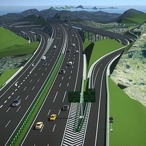
Complete road design with alignment, drainage, and pavement modeling.
Track geometry, overhead structures, and station-area development.
Grading, drainage, and plot planning for townships, campuses, and industrial parks.
Plot layout, utility planning, road access, and quantity estimates.
Model-based scheduling and phasing for optimized site execution.
Overlay engineering with geospatial context for smarter land-use and approvals.
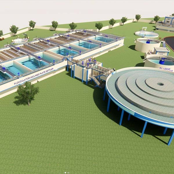
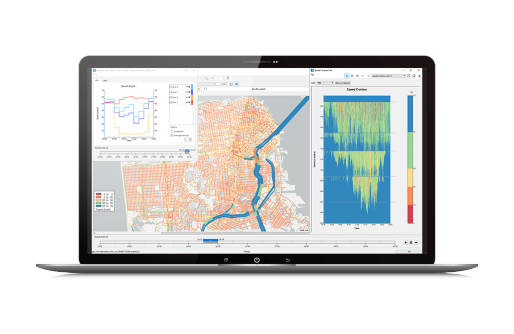
Global water systems are under increasing pressure. Rapid urbanization, climate uncertainty, aging infrastructure, and rising demand are making the delivery of safe, reliable, and efficient water services more complex than ever. Engineering teams are tasked with planning, designing, and managing water networks that must not only meet today’s operational needs but also anticipate tomorrow’s challenges. Without data-driven tools and integrated workflows, water infrastructure projects face inefficiencies, delayed timelines, and high operational risk.
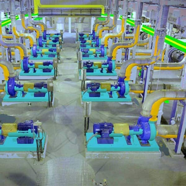
At Mahirut, we provide engineering-centric solutions that enable utilities, municipalities, and infrastructure consultants to digitally transform their water systems. Our platforms integrate simulation, analysis, and lifecycle management to improve network reliability, enhance operational efficiency, and ensure regulatory compliance. From urban water distribution and stormwater drainage to wastewater treatment and flood modeling—Mahirut empowers engineers to deliver smarter, future-ready infrastructure.
Design, simulate, and manage large-scale drinking water networks with dynamic demand.
Evaluate drainage performance and design sustainable urban runoff infrastructure.
Model sewer networks, optimize treatment plant loading, and prevent overflow scenarios.
Simulate hydrologic behavior and develop flood mitigation strategies with precision.
Ensure process reliability and optimize resource use in closed-loop or treated systems.
Enable precision irrigation, canal network optimization, and water reuse strategies.
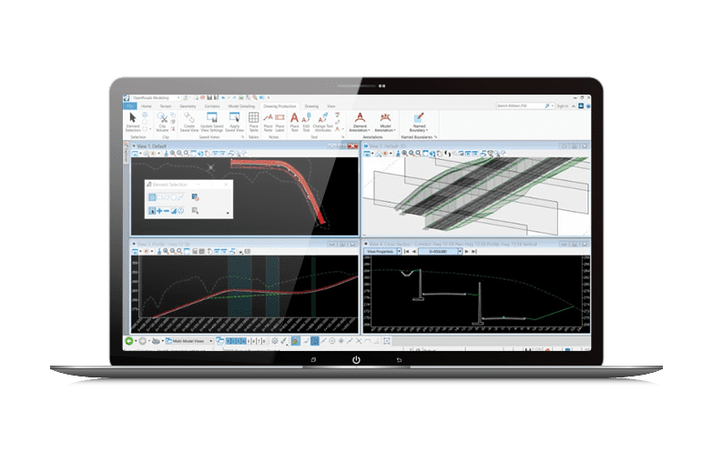
Today’s infrastructure projects are more complex, multidisciplinary, and time-sensitive than ever. Engineering teams are expected to produce accurate, standards-compliant designs across 2D and 3D environments while navigating tight timelines and collaborative constraints. Conventional drafting tools often fall short—lacking interoperability, performance at scale, and real-time coordination. This leads to fragmented data, inefficiencies, and costly design errors that impact delivery and execution.
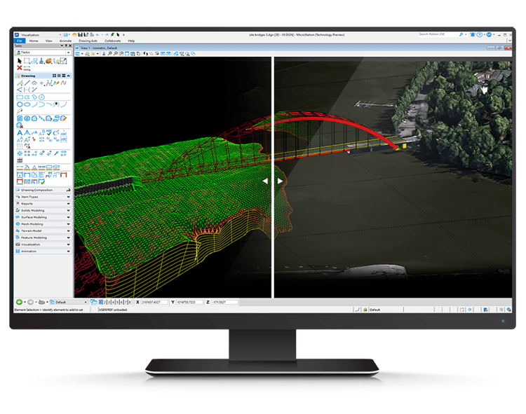
At Mahirut, we deliver cutting-edge design capabilities powered by MicroStation—the infrastructure design platform of choice for high-performance 2D and 3D CAD. From drafting and annotation to visualization and model-based design, Mahirut helps civil, structural, architectural, and utility teams bring precision, control, and clarity to every stage of their design process. Our solution is built for infrastructure scale—empowering seamless collaboration, robust performance, and intelligent workflows.
2D/3D alignment modeling, cross-sections, and right-of-way planning.
Architectural drafting, façade detailing, and site planning.
Design of above-ground and underground utility layouts, pole networks, and fiber routing.
Detailed structure modeling, clash detection, and track alignment.
Topographic modeling, parcel planning, and cut-fill analysis.
Design with real-world context using integrated GIS and terrain data.
Urban infrastructure is evolving fast, but traditional transportation and pedestrian modeling tools are lagging behind. Planners, engineers, and city authorities struggle with siloed systems that fail to capture real-world movement patterns—leading to inefficient layouts, unsafe zones, and costly reworks. In today’s dynamic cities, infrastructure decisions must be informed by accurate simulations of how people and vehicles actually move across environments—indoors and outdoors.
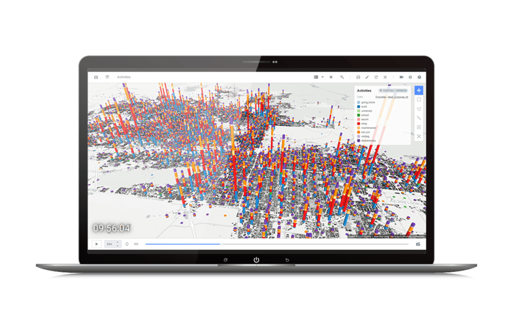
At Mahirut, we bring intelligence and insight to mobility and pedestrian infrastructure with our OpenPath-powered simulation solutions. OpenPath allows planners, architects, and engineers to digitally simulate pedestrian behavior, vehicle movement, and space utilization—helping you design safer, more accessible, and efficient spaces. From rail stations and airports to campuses and commercial hubs, Mahirut helps you evaluate how design impacts human experience, safety, and system performance.
Optimize entry/exit points, seating arrangements, and crowd flow during events.
Model passenger transfer between buses, trains, metros, and terminals.
Design safe evacuation routes, common areas, and wayfinding logic.
Plan passenger flows through security, customs, and boarding zones.
Evaluate circulation in retail, residential, and commercial spaces for better spatial planning.
Ensure accessible, fast movement for patients and staff under routine and emergency conditions.
Construction projects today are more dynamic, collaborative, and schedule-critical than ever before. Yet, many projects still rely on fragmented schedules, outdated spreadsheets, and disconnected workflows to plan and execute billion-dollar infrastructure. These manual approaches create blind spots in decision-making, increase the risk of delays, and inflate budgets. Engineering and construction teams need smarter tools that link design intent with real-time construction progress to ensure every move on site is deliberate, efficient, and coordinated.
Mahirut enables construction professionals to confidently plan, visualize, and deliver complex infrastructure with Synchro—a leading 4D/5D construction management platform. Our Synchro-based solutions connect design models, time, cost, and field data into one integrated construction environment. This empowers project managers, planners, and site engineers to simulate builds, track real-time progress, optimize resources, and drive execution—all from a centralized digital workspace.

Simulate and sequence roads, railways, bridges, and metro projects.
Coordinate site development with underground utilities, landscaping, and public spaces.
Deliver complex structures with precision sequencing and resource optimization.
Manage time-sensitive shutdowns and large-scale equipment installations.
Keep your project on track with mobile-based progress tracking and automated field reporting.
